Disaster Management forms a distinct part of the syllabus of General Studies III as well as Geography optional Paper II. In the current scenario where climate change has already set in and the frequency and intensity of natural disasters are increasing, this topic assumes supreme importance. Disaster Managemnet, thus, is a must know for all IAS aspirants.
- IPCC Report says both frequency and magnitude of natural disasters are on the rise.
- Vulnerability of India
- 85% area vulnerable to one or more types of disasters
- 68% area prone to drought
- 28 states and UTs are vulnerable
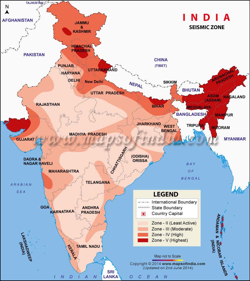
- 57% of area under high seismic zones
EARTHQUAKE
- Himalayan & Indo-Ganga Basin states, Rann of Kutch, Gulf of Khambat, Western Gujarat, Parts of peninsular India, Andaman & Nicobar, Lakshadweep
- Requires mitigation, preparedness, effective/expeditious rescue, safe built environment, seismic retrofitting.
- Microzonation (google it) and zone-specific planning needed
- Map of Seismic Zonation should be grossly remembered. Notice that there is no Zone I as it has been merged with Zone II

CYCLONES
- ~8000 km coastal length
- ~20% of the population resides in coastal areas
- East coast more vulnerable than west coast
- Only 25% of Arabian Sea cyclones hit the west coast (Why?)
- 60% of Bay of Bengal cyclones hit the East Coast
- Forecast and warning services particularly for fisheries, marine shipping, ports etc.
- Cyclone shelters for evacuation
- e.g. Phailin Cyclone, 2013, Odisha evacuated 1 million people, minimal loss
- Compare Phailin with 1999 cyclone in Odisha which killed about 10,000 people.
FLOODS
- Floods occur when waterflows cannot be contained within the natural or artificial banks
- Assam and Bihar are most flood prone, followed by West Bengal and Uttar Pradesh
- Freak weather due to climate change causing floods even in Rajasthan (2006)
- Bundelkhand suffered 3 consecutive drought years followed by sudden flood in 2016
- Urban floods are mostly man-made disasters
- Management of flood plains, drainage channels, forecast, warning, building regulations etc. needed
- Dams should be built with siltation planning and not just waterflow planning
Traditional Knowledge in Disaster Management
- Andaman tribes were relatively safer during 2004 Tsunami due to Traditional Knowledge
- Assam bamboo stilt houses as hedge against floods
- Uttarakhand earthquake was devastating but wooden/stone houses of traditional types were safe
- This community intelligence needs to be tapped while making Disaster Management plans
Flood Control and Management (National Water Policy)
- Masterplan for each flood-prone basin.
- Developmental needs may be sacrificed in highly flood-prone areas for reservoir regulation
- Strict regulation of settlement and economic activity in flood plains
- Structural measures (dykes/embankments) needed but more emphasis should be on non-structural measures like forecasting, floodproofing and mitigation
- Modernisation of forecasting infrastructure
LANDSLIDE
- Himalayan region vulnerable due to tectonic instability
- Western Ghats and Nilgiri vulnerable due to uplifted nature of plateau (tectonically stable but overburdened)
- Measures to be taken
- regulate settlement using ‘microzonation’
- ‘grouting’ and fencing by retaining-walls
- Frreing up of flood channels
DROUGHTS
- High annual average rainfall in India but huge spatial and temporal variation
- >8-0% rain concentrated in South-West Monsoon
- 21% area gets less than 700 mm rainfall (drought prone)
- Per capita water availability is declining
- Groundwater level dropping rapidly
- Look up new definitions of drought by IMD
Supplement this information with the Disaster Management chapter in NCERT Geography book. Learn about Hyogo Framework, BRICS Udaipur Declaration and National Disaster Management Plan.
I will soon upload my brief notes on Sendai Framework for Disaster Risk Reduction